
Site Survey
Boundary identification — know where your plot ends before you build
We survey your plot against your tippani and title documents, locate the boundary on the ground and mark the corners — so your compound wall and building sit inside your own land.
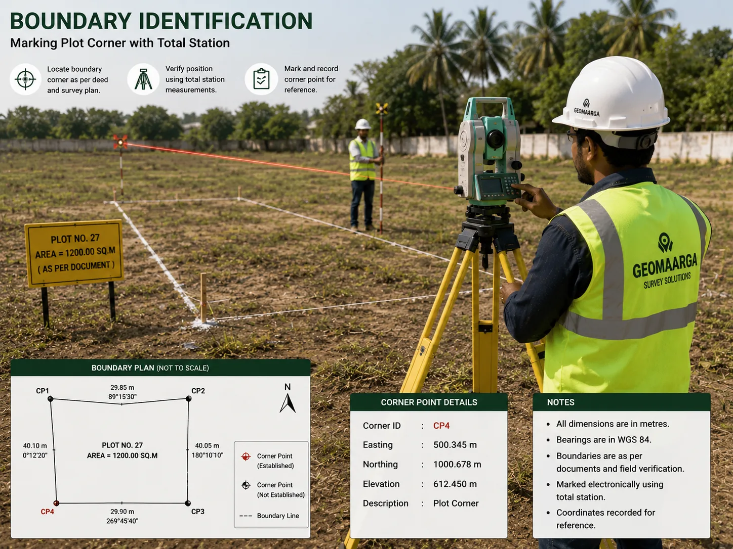
We survey to your tippani and documents
Your tippani, sale deed, layout plan and any earlier survey drawing describe where the boundary runs. We take those documents, locate that line on the ground with survey-grade instruments, mark the corners permanently and report the measured area against the recorded extent.
That gives your architect and your contractor a boundary they can build to with confidence. It is an engineering survey based on the documents you provide — it is not a legal demarcation and should not be treated as one. Cadastral certification is issued by the government revenue authorities and by surveyors licensed under state law.
What you get
Agreed in the quotation before we mobilise. A boundary identification normally delivers:
- Plot corners marked physically on the ground, so your team can work to them
- Drawing in DWG, DXF and PDF showing the boundary, corner positions and measured area
- Measured area of the plot, compared against the area stated in your documents
- Corner coordinate schedule, so a disturbed mark can be reinstated without a fresh survey
- Photographs of each corner mark as placed
- A clear note of any place where the ground and your documents do not agree
- Survey report stating method, instruments, coordinate system and accuracy
What we need from you
We are locating the boundary your documents describe. So the documents matter as much as the measuring. Send whatever you have:
- Sale deed
- Approved layout plan, if the plot is part of a layout
- Tippani or sketch
- Khata details
- Any earlier survey drawing, even an old or informal one
- Any conversion or approval order relating to the land
More is better. Where documents disagree with each other — which happens often — we will show you what each one implies rather than quietly choosing between them.
If you have no documents at all, we can still measure what is physically on the ground today: walls, fences, existing marks. But that is a measurement of the present situation, not an identification of your boundary, and we will describe it that way on the drawing.
When you need this
- Before building a compound wall, so it goes on your land and not next door's
- Before starting construction, so setbacks are measured from the right line
- Before buying a plot, to check the extent matches what is being sold
- When the plot has been vacant for years and the old marks are gone
- When you suspect the area is less than the documents say
- When a neighbour has built close to the line and you want to know where it is
- Before subdividing land between family members

When the ground and the paper disagree
This is the situation people most often call us about, and it is worth being plain about how we handle it.
A compound wall may sit a metre inside the documented line, or a metre outside it. The measured area may come out smaller than the deed states. Two documents may describe the same plot differently. An old boundary stone may not be where anyone expects.
We report what we find. Both positions go on the drawing — where your documents place the boundary, and where the physical features actually are — with the difference measured and stated. We do not choose the answer that makes the client happier, and we do not smooth over a discrepancy to keep a job simple.
Our part is to give you an accurate measurement, clearly reported, so that whatever you decide next is decided on facts rather than assumptions.
Accuracy you can expect
Corner positions are measured to the same standard as any of our engineering work.
| Method | Horizontal accuracy | Used where |
|---|---|---|
| Total station on adjusted traverse | ±10–20 mm | Built-up plots, tree cover, narrow lanes |
| DGPS, RTK | ±8 mm + 1 ppm | Open plots and larger parcels |
| DGPS, static post-processed | ±2.5 mm + 0.5 ppm | Control the corner measurements are taken from |
Figures are typical achievable tolerances for survey-grade equipment under reasonable field conditions, not a contractual guarantee. Note that measurement accuracy is not the same as certainty about the boundary — a corner can be measured to millimetres and still sit where an ambiguous document only approximately places it. The limit is usually the paperwork, not the instrument.
Typical applications
- Before a compound wallCorners marked so the wall is built inside your own land
- Before construction startsSetbacks measured from a boundary that has been located, not assumed
- Buying a plotExtent and measured area checked against what is being sold
- Long-vacant landBoundary re-established where old marks have been lost
- Family subdivisionParcel extents measured and marked before division
- Layout and plotted developmentIndividual plot corners set out from the approved layout
Related reading
Boundary work is usually combined with a wider survey — most clients who need their corners marked also need levels and existing features recorded, which is a topographic survey. The measurement methods behind both are the same.
- Total station or DGPS — how we choose the method
- GPS vs DGPS — the differential principle
- Why satellite levels are not sea levels
Related services
- Topographic Survey — boundary plus levels and every existing feature
- Total Station Survey — the method for built-up plots
- DGPS Survey — for open plots and larger parcels
- Contour Survey — how the land slopes
- Construction Survey — setting the building out once the boundary is known
- All site survey services
How we work
How we identify a boundary
-
Study your documents
Deed, layout plan, sketch and any earlier survey read together, before anyone goes to site, so we know what we are looking for.
-
Look for existing evidence
Old boundary stones, walls, fences and marks on site located and measured. These often matter more than anything else in deciding where the line runs.
-
Establish control
Reference points set and checked, so every corner is measured from a framework rather than from a tape run between assumptions.
-
Set out the corners
Boundary positions computed from your documents, set out on the ground, and compared against the physical evidence already recorded.
-
Mark and record
Corners marked physically, coordinates recorded and each mark photographed, so a disturbed corner can be reinstated later.
-
Report, including the disagreements
Drawing and report issued showing measured area, corner positions, and any place where the ground and your documents do not agree.
Questions
Boundary identification FAQs
We can show you exactly where your tippani and documents place the boundary, and mark it on the ground so you can build inside your own land. That is often enough to settle an honest misunderstanding between neighbours. What our marking does not do is bind either party in law. Where a disagreement is genuine and may go to court, legal demarcation comes from the government revenue authorities or a surveyor licensed under state law.
Whatever describes the plot: the tippani, the sale deed, the approved layout plan, khata details, and any earlier survey drawing. The more you can give us the better, because we are locating the boundary your documents describe. Without documents there is nothing to identify the boundary against, and we can only measure what is physically on the ground today.
This is common, and we will tell you plainly rather than pick whichever answer you would prefer. A compound wall may sit inside or outside the documented line; the measured area may differ from the recorded extent; two documents may disagree with each other. We report exactly what we find, show both the documented position and the physical position on the drawing, and leave the decision about what to do to you and your legal advisor.
Our work is carried out for engineering and construction purposes, so it should not be relied on as evidence. Court proceedings normally require a survey by an authority appointed for the purpose. Tell us at the outset if the matter is contested and we will point you to the right route before you spend anything.
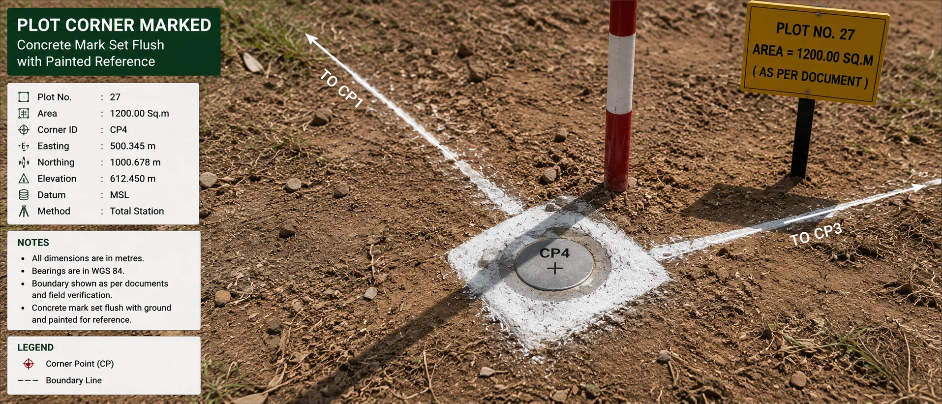
Plot corners are marked physically so your team can see and work to them — usually a concrete or stone mark, or a marked peg where the ground does not allow one. Corner coordinates are recorded, so if a mark is disturbed during construction it can be reinstated from the record without a fresh survey. We photograph each mark as part of the record.
Someone who knows the site should meet our team at the start, to confirm access and point out which boundaries you believe apply. Whether to inform your neighbour is your decision, but where a shared boundary is being marked it usually avoids trouble later if they know the work is happening. We do not act as a go-between in any disagreement.